Mexico City is dropping into the earth at a rate of up to two centimeters every single month, translating to nearly ten inches a year in its hardest-hit districts. This extreme pace of land subsidence, recently mapped with unprecedented clarity by the joint NASA-ISRO Synthetic Aperture Radar (NISAR) satellite mission, cements the Mexican capital as one of the fastest-sinking metropolises on the planet. The core cause is not a mystery of geology, but a consequence of human engineering. For over a century, the city has relentlessly pumped drinking water from the underlying regional aquifer, causing the soft clay of the ancient lakebed beneath the streets to compact permanently under the crushing weight of 22 million residents.
But the real threat facing Mexico City is not that the entire valley is dropping uniformly. It is the invisible, uneven fracturing of the urban landscape known as differential subsidence.
The Mirage of Uniform Descent
When space agencies publish color-coded maps showing a city turning dark blue under radar telemetry, the public imagination tends to picture an entire metropolis dropping into the earth like a slow-moving elevator. The reality observed on the ground is far more chaotic.
The Basin of Mexico is a naturally closed depression where the Aztec capital of Tenochtitlán once thrived on a series of lakes. When the Spanish conquered the region, they drained the water and built a stone city over highly compressible, water-saturated volcanic clay layers that reach up to 100 meters thick in some sectors. As groundwater extraction sucks the pore pressure out of these clay formations, they shrink.
Crucially, they do not shrink evenly.
A neighborhood built on the shallow edge of the ancient lakebed might remain relatively stable. A mile away, a high-rise corridor built over the deepest pocket of soft sediment sinks rapidly. Remote sensing data shows that while some urban sectors experience minimal movement, others plunge by up to 50 centimeters annually. This violent contrast occurs not just between distant neighborhoods, but across single city blocks.
Consider a hypothetical 100-yard stretch of concrete. If the northern end drops by three inches in a year while the southern end stays anchored to a shallower layer of basalt rock, the structural integrity of anything built on top of that line is compromised. The ground literally tears itself apart.
The Destruction of Invisible Infrastructure
The most visible symptoms of this crisis are frequently treated as local curiosities. Tourists routinely photograph the Angel of Independence monument on the Paseo de la Reforma, pointing out the 14 stone steps that engineers have had to add to its base since its construction in 1910. Because the monument's heavy foundation is anchored deep into stable strata via piles, it stays put while the surrounding avenue drops away around it. The monument is not rising; Mexico City is falling.
Behind these architectural anomalies lies a massive infrastructure failure. The structural warping ruins the city’s lifelines.
- The Aqueduct Paradox: The city relies on groundwater for roughly 58% of its total water supply. As the ground sinks, it breaks the very network of pipes distributing that water. The municipal system loses an estimated 40% of its potable water to subterranean leaks caused by ground deformation before it ever reaches a tap.
- The Subway Failure: The Metro system, which moves millions of commuters daily, faces continuous track warping. Sections of the network require frequent structural reinforcement and speed restrictions because differential settling bends steel rails out of alignment.
- The Sewage Nightmare: Gravity is the fundamental force driving urban drainage. Originally, Mexico City's main sewage lines sloped downward out of the valley. Due to decades of uneven sinking, major collector mains have lost their slope or completely reversed direction. The city must now rely on massive, energy-intensive pumping stations to force wastewater uphill out of the basin to prevent catastrophic flooding during the rainy season.
The Limits of the Aquifer
The mainstream narrative often frames this purely as a problem of municipal management, suggesting that if the city simply stopped pumping from the aquifer, the sinking would halt. This oversimplifies a brutal hydrogeological reality.
Mexico City has few viable alternatives for water. The Cutzamala System, an intricate network of reservoirs, pumping stations, and pipelines that imports water from outside the basin, provides much of the remaining supply. However, this imported water is highly vulnerable to climate variability, recurring droughts, and intense political conflict with rural communities in neighboring states who resent their resources being siphoned away by the capital.
Furthermore, halting groundwater extraction does not instantly solve the problem. Ten years of continuous monitoring at instrumented research sites using piezometers and extensometers reveal a sobering fact: once the clay layers lose their pore pressure and compact, the deformation is largely irreversible. The storage capacity of the aquifer is permanently destroyed.
The weight of the city itself also plays a larger role than previously acknowledged. While groundwater extraction remains the primary driver of subsidence, recent geotechnical modeling shows that the sheer structural load of modern high-rises and heavy highway infrastructure accounts for roughly 10% to 15% of the total compaction in high-density zones. The city is actively burying itself under its own weight.
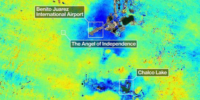
High-Resolution Surveillance from Orbit
Past satellite missions could track large-scale subsidence, but they were often limited by cloud cover, vegetation on the city's fringes, or long revisit times between passes. The deployment of the NISAR satellite alters this operational dynamic.
Utilizing an advanced L-band synthetic aperture radar system, the satellite can pierce heavy cloud layers and dense urban haze, collecting detailed data day and night. The preliminary readings taken between October 2025 and January 2026 provided the most precise diagnostic map of the capital’s structural failure ever compiled.
The radar data highlighted Benito Juárez International Airport and the Valley of Chalco as epicenters of intense subsidence, registering movements well over the two-centimeter-per-month threshold. For an airport, uneven runway settlement is not an aesthetic flaw; it is a critical safety hazard that requires constant, expensive resurfacing.
Geophysicists are now using this real-time data flow to transition from broad regional assessments to building-by-building scales. This spatial resolution allows engineers to identify which specific hospital foundations, subway overpasses, and water mains are approaching their structural breaking points before a catastrophic failure occurs.
No Easy Way Out
Every proposed remedy for Mexico City's subsidence comes with a prohibitive trade-off.
Artificial aquifer recharge—injecting treated wastewater back into the ground to restore pore pressure—is frequently championed by urban planners. However, the sheer volume of water required to offset the daily extraction of a megalopolis of 22 million people is staggering. The energy costs alone would strain the national electrical grid, and the risk of contaminating the remaining deep freshwater reserves with inadequately treated surface runoff remains a serious concern among water scientists.
Shifting entirely to imported water requires infrastructure projects that would take decades and billions of dollars to construct, with no guarantee that neighboring regions will have surplus water to give as climate patterns shift.
The satellite data provided by the NISAR mission is an alarm bell for an impending structural crisis. Mexico City is running out of water, and the act of searching for it deeper underground is destroying the physical foundation upon which the city stands. The metropolis is locked in a feedback loop where the cure directly accelerates the disease, leaving its infrastructure to fracture quietly under the weight of an irreversible descent.